(1 of 3) ...HIGH WIND WARNING IN EFFECT FROM 11 AM MST /NOON MDT/ TO 7 PM MST /8 PM MDT/ TUESDAY... * WHAT...For the Wind Advisory, southwest winds 20 to 30 mph with gusts from 35 to 45 mph. For the High Wind Warning, southwest winds 30 to 40 mph with gusts from 50 to 60 mph. * WHERE...Little Colorado River Valley. * WHEN...For the Wind Advisory, from 11 AM MST /noon MDT/ this morning to 7 PM MST /8 PM MDT/ this evening. For the High Wind Warning, from 11 AM MST /noon MDT/ to 7 PM MST /8 PM MDT/ Tuesday. * IMPACTS...Travel will be difficult, especially for high profile vehicles. Areas of blowing dust will lead to reduced visibilities, resulting in hazardous driving conditions. Gusty winds will blow around unsecured objects. (2 of 3) MST Mon May 12 2025/ ...RED FLAG WARNING IN EFFECT FROM 11 AM MST /NOON MDT/ THIS MORNING TO 7 PM MST /8 PM MDT/ THIS EVENING DUE TO STRONG WINDS AND LOW RELATIVE HUMIDITY FOR THE WHITE MOUNTAINS NORTHWARD TO THE CHUSKA MOUNTAINS... ...RED FLAG WARNING IN EFFECT FROM 11 AM MST /NOON MDT/ TO 7 PM MST /8 PM MDT/ TUESDAY DUE TO STRONG WINDS AND LOW RELATIVE HUMIDITY FOR THE WHITE MOUNTAINS NORTHWARD TO THE CHUSKA MOUNTAINS... The National Weather Service in Flagstaff has issued a Red Flag Warning due to strong winds and low relative humidity, which is in effect from 11 AM MST /noon MDT/ this morning to 7 PM MST /8 PM MDT/ this evening. A Red Flag Warning has also been issued from 11 AM MST /noon MDT/ to 7 PM MST /8 PM MDT/ Tuesday. * AFFECTED AREA...Locations near Alpine, Buffalo Pass, Eagar and Springerville, Ganado, Pinetop-Lakeside, Saint Johns, Show Low, Whiteriver and Window Rock. This includes portions of the Apache-Sitgreaves National Forest. * WINDS...Southwest 15 to 25 mph with gusts from 35 to 40 mph Monday, increasing to 20 to 35 mph with gusts from 50 to 60 mph on Tuesday. * RELATIVE HUMIDITY...As low as 10 percent. * IMPACTS...The combination of gusty winds and low humidity can cause fires to rapidly grow in size and intensity before first responders can contain them. (3 of 3) MST Mon May 12 2025/ ...RED FLAG WARNING IN EFFECT FROM 11 AM MST /NOON MDT/ THIS MORNING TO 7 PM MST /8 PM MDT/ THIS EVENING DUE TO STRONG WINDS AND LOW RELATIVE HUMIDITY FOR THE WHITE MOUNTAINS NORTHWARD TO THE CHUSKA MOUNTAINS... ...RED FLAG WARNING IN EFFECT FROM 11 AM MST /NOON MDT/ TO 7 PM MST /8 PM MDT/ TUESDAY DUE TO STRONG WINDS AND LOW RELATIVE HUMIDITY FOR THE WHITE MOUNTAINS NORTHWARD TO THE CHUSKA MOUNTAINS... The National Weather Service in Flagstaff has issued a Red Flag Warning due to strong winds and low relative humidity, which is in effect from 11 AM MST /noon MDT/ this morning to 7 PM MST /8 PM MDT/ this evening. A Red Flag Warning has also been issued from 11 AM MST /noon MDT/ to 7 PM MST /8 PM MDT/ Tuesday. * AFFECTED AREA...Locations near Alpine, Buffalo Pass, Eagar and Springerville, Ganado, Pinetop-Lakeside, Saint Johns, Show Low, Whiteriver and Window Rock. This includes portions of the Apache-Sitgreaves National Forest. * WINDS...Southwest 15 to 25 mph with gusts from 35 to 40 mph Monday, increasing to 20 to 35 mph with gusts from 50 to 60 mph on Tuesday. * RELATIVE HUMIDITY...As low as 10 percent. * IMPACTS...The combination of gusty winds and low humidity can cause fires to rapidly grow in size and intensity before first responders can contain them.
RepeaterBook.com Home Page
honey pot Wenden, Arizona, 462.550, WRPH450 Repeater

Wenden, AZ

WRPH450

GMRS Repeater ID: 04-443
Downlink: 462.550
Uplink: 467.550
Uplink Tone: LOG IN TO VIEW
Downlink Tone: LOG IN TO VIEW
County: La Paz
GPS*:
Owner: WRPH450
Use: OPEN
Op Status: ON-AIR On-Air
Marker
50 km
30 mi
Leaflet © OSM contributors

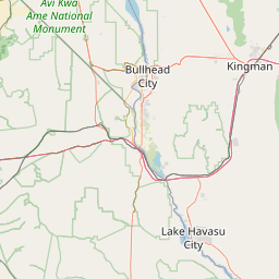
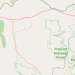
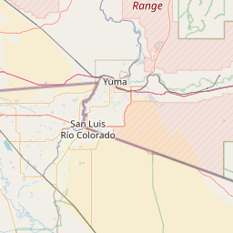
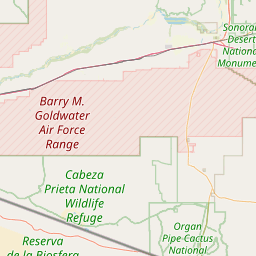
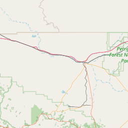
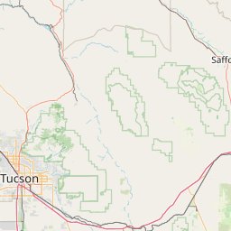
Exact coordinates of the repeater are not known.
Coverage circle based on mobile coverage and ignores propagation anomalies and terrain.

Signal Reports (click map icon for details): Base Mobile HT
Add a Signal Report