(1 of 3) ...The National Weather Service in Newport/Morehead City NC has issued a Flood Warning for the following rivers in North Carolina... Trent River At Trenton affecting Jones County. For the Non-forecast Points (warnings)...including Swift Creek at Vanceboro, Pollocksville, Bogue Sound at HWY 58 at Emerald Isle, Farmville, Rock Springs, Grimesland, Grifton, Gum Branch, Washington, Parker Creek Above Greenville, Simpson, Spring Garden, Little Contentnea Creek Near Ayden, Beulaville, Oak City, Streets Ferry, Green Mill Run in Greenville, Hamilton, New River at Jacksonville, Johnsons Mill Run Near Greenville, Trenton...Minor flooding is forecast. * WHAT...Minor flooding is occurring and minor flooding is forecast. * WHERE...Trent River at Trenton. * WHEN...From this afternoon until further notice. * IMPACTS...At 14.0 feet, Boat Launch area at the end of Landfill Road is flooded, and parts of Landfill Road may be flooded. The end of West Jones Street is inundated as well. * ADDITIONAL DETAILS... - At 12:20 PM EDT Wednesday the stage was 14.1 feet. - Recent Activity...The maximum river stage in the 24 hours ending at 12:20 PM EDT Wednesday was 14.1 feet. - Forecast...The river will continue to rise slowly for the rest of today, and likely crest sometime tonight. - Flood stage is 14.0 feet. - http://www.weather.gov/safety/flood (2 of 3) ...Observed flooding changed to Minor severity and increased in duration for the following rivers in North Carolina... New River At Gum Branch affecting Onslow County. * WHAT...Minor flooding is occurring. * WHERE...New River at Gum Branch. * WHEN...Until further notice. * IMPACTS...At 14.0 feet, Water threatens homes at the end of Forest Bluff Drive. Minor farmland flooding along the river occurs. * ADDITIONAL DETAILS... - At 11:45 AM EDT Wednesday the stage was 14.3 feet. - Recent Activity...The maximum river stage in the 24 hours ending at 11:45 AM EDT Wednesday was 14.3 feet. - Forecast...The river has likely crested and will begin to fall this afternoon. - Flood stage is 14.0 feet. - http://www.weather.gov/safety/flood (3 of 3) ...The Flood Warning continues for the following rivers in North Carolina... Cape Fear River At William O Huske Lock And Dam 3 affecting Cumberland and Bladen Counties. * WHAT...Minor flooding is forecast. * WHERE...Cape Fear River at William O Huske Lock And Dam 3. * WHEN...Until Friday evening. * IMPACTS...At 42.0 feet, Water levels will top the navigational lock and equipment must be removed. Minor flooding will occur on land adjacent to the east bank of the river. * ADDITIONAL DETAILS... - At 10:00 AM EDT Wednesday the stage was 40.9 feet. - Forecast...The river is expected to rise above flood stage late this afternoon to a crest of 43.0 feet just after midnight tonight. It will then fall below flood stage early Saturday afternoon. - Flood stage is 42.0 feet. - weather.gov/safety/flood
honey pot Hertford, North Carolina, 441.85, WB4YNF Repeater

Hertford, NC

WB4YNF
Repeater ID: 37-22833

Downlink: 441.85000
Uplink: 446.85000
Offset: +5.000 MHz
System Fusion Enabled
DG-ID:
County: Perquimans
Call: WB4YNF
Use: OPEN
Op Status: ON-AIR On-Air
Coverage: Windsor to Elizabeth City to Columbia to Plymouth
30 mi radius.
Sponsor: WB4YNF
Features: Emergency power equipped.
Coordination: SERA
Last updated: 2024-09-18
Last reviewed: 2025-04-29
Marker
30 km
30 mi
Leaflet © OSM contributors

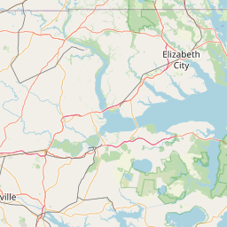
Exact coordinates of the repeater are not known.
Coverage circle based on mobile coverage and ignores propagation anomalies and terrain.

Signal Reports (click map icon for details): Base Mobile HT
Add a Signal Report


Call Date Details
WB4YNF (registered) 2024-09-18 Added.