(1 of 3) ...The Flood Warning continues for the following rivers in Tennessee... Tennessee River at Johnsonville For the Tennessee River...including Johnsonville...Minor flooding is forecast. * WHAT...Minor flooding is occurring. * WHERE...Tennessee River at Johnsonville. * WHEN...Until Saturday morning. * IMPACTS...At 361.5 feet, Low-lying portions of Old Johnsonville Road near the Battle of Johnsonville Park begin to flood, and water approaches some of the parking areas and campgrounds at Mason's Boat Dock near Waverly. * ADDITIONAL DETAILS... - At 8:00 AM CDT Tuesday the stage was 362.2 feet. - Forecast...The river will fluctuate near 362 feet for a couple of days. It will then begin to fall and is expected to fall below flood stage Friday morning. - Flood stage is 361.5 feet. - http://www.weather.gov/safety/flood (2 of 3) ...The Flood Warning is extended for the following rivers in Tennessee... South Fork of the Forked Deer near Halls For the South Fork Forked Deer River...including Halls...Minor flooding is forecast. * WHAT...Minor flooding is occurring. * WHERE...South Fork of the Forked Deer near Halls. * WHEN...Until Friday morning. * IMPACTS...At 12.5 feet, Water is flowing over Highway 210 north of Halls. Several low-lying roads near the South Fork of the Forked Deer River are flooded. * ADDITIONAL DETAILS... - At 9:00 AM CDT Tuesday the stage was 12.0 feet. - Forecast...The river will continue to fall and is expected to fall below flood stage early Friday morning. - Flood stage is 9.0 feet. - http://www.weather.gov/safety/flood (3 of 3) ...The Flood Warning continues for the following rivers in Tennessee... Obion River near Bogota For the Obion River...including Bogota...Minor flooding is forecast. * WHAT...Minor flooding is occurring. * WHERE...Obion River near Bogota. * WHEN...Until Thursday evening. * IMPACTS...At 22.0 feet, Widespread lowland and agricultural flooding is occurring. Water is reaching the outskirts of Bogota. * ADDITIONAL DETAILS... - At 9:00 AM CDT Tuesday the stage was 22.8 feet. - Forecast...The river will continue to fall and is expected to fall below flood stage early Thursday afternoon. - Flood stage is 22.0 feet. - http://www.weather.gov/safety/flood
RepeaterBook.com Home Page
honey pot Huntingdon, Tennessee, 147.33, KG4LTU Repeater

Huntingdon, TN

KG4LTU
Repeater ID: 47-21854

Downlink: 147.33000
Uplink: 147.93000
Offset: +0.600 MHz
Uplink Tone: 131.8
Downlink Tone: 131.8
County: Carroll
Call: KG4LTU
Use: OPEN
Op Status: ON-AIR On-Air
Coverage: Estimated Area Coverage:
13 mi radius.
Pattern: Omnidirectional
Affiliate: SERA
FM: Yes; analog capable.
Analog Bandwidth: 25.0 kHz (wideband)
Notes: SERA Listing (as of 10 October 2023): KG4LTU 147.3300 +0.6 MHz 131.8 Wideband FM Huntingdon Carrol

RB: There is no Repeater Record Custodian (RRC) assigned to this repeater. KG4LTU -- JAMES L. WOFFORD -- TRUSTEE must first obtain a Repeaterbook.com account before being added as an RRC. Please ask KG4LTU to register for an RB account.
Web links: Sponsor: KG4LTU -- JAMES L. WOFFORD -- TRUSTEE.
Coordination: SERA
Last updated: 2023-10-09
Last reviewed: 2025-04-11
30 km
30 mi
Leaflet | © OpenStreetMap, © OpenStreetMap contributors

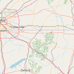
Exact coordinates of the repeater are not known. Location is approximate.

Add a Propagation Report

- Base - HT - Mobile
Click the icons on map for details.


Call Date Details
KQ4VTH (registered) 2025-04-12 Propagation Report Added
N9EXR (registered) 2024-05-15 Reported no changes
KN4GVD (registered) 2023-10-08 County changed to Carroll. Operational status changed to on-air.
KN4GVD (registered) 2023-08-06 Added.


Searches Stats Wiki Account About
D-Star Repeaters Overall Stats Start Page Log in Contact Us
DMR Repeaters Current Status Subscriptions FAQs
P-25 Repeaters Newsletter Legal
Proximity 2.0 Ad Free


Stay Connected

Copyright © 2006-2025 RepeaterBook.com. All Rights Reserved.
Created and owned by KD6KPC/WREQ745 since 2006.
All data, including non-copyrightable data, is protected from theft under Oregon law (ORS 164.377).

Page created in 0.101543 seconds.