(1 of 5) ...The Flood Warning continues for the following rivers in Wisconsin... Wisconsin River below Biron Reservoir affecting Wood County. * WHAT...Minor flooding is occurring. * WHERE...Wisconsin River below Biron Reservoir. * WHEN...Until further notice. * IMPACTS...At 1017.0 feet, Widespread wooded lowland flooding. Water approaches a few homes on South Biron Drive in Biron. * ADDITIONAL DETAILS... - At 1:10 PM CDT Monday the stage was 1017.1 feet. - Bankfull stage is 1015.0 feet. - Recent Activity...The maximum river stage in the 24 hours ending at 1:10 PM CDT Monday was 1017 feet. - Forecast...No forecast is available for this location. - Flood stage is 1017.0 feet. - http://www.weather.gov/safety/flood (2 of 5) ...The Flood Warning continues for the following rivers in Wisconsin... Yellow River at Babcock affecting Wood County. For the Yellow River...including Babcock...Minor flooding is forecast. * WHAT...Minor flooding is occurring and minor flooding is forecast. * WHERE...Yellow River at Babcock. * WHEN...Until Tuesday morning. * IMPACTS...At 12.0 feet, Flooding is confined mainly to agricultural...wooded lowland and marshes. * ADDITIONAL DETAILS... - At 10:00 AM CDT Monday the stage was 12.6 feet. - Bankfull stage is 10.0 feet. - Recent Activity...The maximum river stage in the 24 hours ending at 10:00 AM CDT Monday was 12.6 feet. - Forecast...The river will remain just above flood stage into this afternoon, then fall below flood stage late this evening and to 6.8 feet by early Thursday morning. The river will rise again to around 9.0 feet late Saturday afternoon into Sunday morning. - Flood stage is 12.0 feet. - http://www.weather.gov/safety/flood (3 of 5) ...The Flood Warning continues for the following rivers in Wisconsin... Wisconsin River below Whiting Dam affecting Portage County. Wisconsin River below Stevens Point affecting Portage County. Wisconsin River below Wausau affecting Marathon County. * WHAT...Minor flooding is occurring. * WHERE...Wisconsin River below Stevens Point. * WHEN...Until further notice. * IMPACTS...At 1076.0 feet, There is widespread flooding of wooded lowland areas. * ADDITIONAL DETAILS... - At 7:10 AM CDT Monday the stage was 1076.6 feet. - Bankfull stage is 1074.0 feet. - Recent Activity...The maximum river stage in the 24 hours ending at 7:10 AM CDT Monday was 1076.7 feet. - Forecast...No forecast is available for this location. - Flood stage is 1076.0 feet. - http://www.weather.gov/safety/flood (4 of 5) ...The Flood Warning continues for the following rivers in Wisconsin... Wisconsin River below Whiting Dam affecting Portage County. Wisconsin River below Stevens Point affecting Portage County. Wisconsin River below Wausau affecting Marathon County. * WHAT...Minor flooding is occurring. * WHERE...Wisconsin River below Whiting Dam. * WHEN...Until further notice. * IMPACTS...At 1053.0 feet, Widespread flooding in wooded land adjacent to the river. Floodwaters approach homes in low-lying areas on Park Drive west of Plover. * ADDITIONAL DETAILS... - At 7:10 AM CDT Monday the stage was 1053.5 feet. - Bankfull stage is 1051.0 feet. - Recent Activity...The maximum river stage in the 24 hours ending at 7:10 AM CDT Monday was 1053.6 feet. - Forecast...No forecast is available for this location. - Flood stage is 1053.0 feet. - http://www.weather.gov/safety/flood (5 of 5) ...The Flood Warning continues for the following rivers in Wisconsin... Wisconsin River below Whiting Dam affecting Portage County. Wisconsin River below Stevens Point affecting Portage County. Wisconsin River below Wausau affecting Marathon County. * WHAT...Minor flooding is occurring. * WHERE...Wisconsin River below Wausau. * WHEN...Until further notice. * IMPACTS...At 1167.0 feet, Water approaches buildings in DC Everest Park and Oak Island Park. * ADDITIONAL DETAILS... - At 9:10 AM CDT Monday the stage was 1167.9 feet. - Bankfull stage is 1065.0 feet. - Recent Activity...The maximum river stage in the 24 hours ending at 9:10 AM CDT Monday was 1168.5 feet. - Forecast...No forecast is available for this location. - Flood stage is 1167.0 feet. - http://www.weather.gov/safety/flood
RepeaterBook.com Home Page
honey pot Tomah, Wisconsin, 147.24, KD9JZC Repeater

Tomah, WI

KD9JZC
Repeater ID: 55-21622

Downlink: 147.24000
Uplink: 147.84000
Offset: +0.600 MHz
D-STAR Enabled
Node: KD9JZC (C) Gateway Repeater
County: Monroe
Call: KD9JZC
Use: OPEN
Op Status: ON-AIR On-Air
Coverage: 30 mi radius.
Sponsor: Wisconsin Interstate Network
Links:
System Links:
Full-time internet linked to the Wisconsin Digital Network System.
Notes: Repeater reconnects to REF019B after 15mins of inactivity
Nets: Wednesday Night D-Star Net 1900
Sunday Night D-Star Net 2100
Web links: WI Digital Network
jfindu
dstarusers.org
APRS.fi
Coordination: WAR
Last updated: 2025-01-15
Last reviewed: 2025-01-15
30 km
20 mi
Leaflet | © OpenStreetMap, © OpenStreetMap contributors

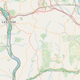
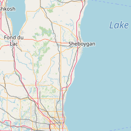
Exact coordinates of the repeater are not known. Location is approximate.

Add a Propagation Report

- Base - HT - Mobile
Click the icons on map for details.


Call Date Details
KC0WKP (registered) 2024-02-01 Propagation Report Added


If you have an iPhone/iPod/iPad or Android device, please download the FREE official RepeaterBook app!


Copyright © 2006-2025 RepeaterBook.com. All Rights Reserved.
Created and owned by KD6KPC/WREQ745 since 2006.
All data, including non-copyrightable data, is protected from theft under Oregon law (ORS 164.377).

Page created in 0.042378 seconds.