(1 of 2) ...The Flood Warning continues for the following rivers in Georgia... Altamaha River At Charlotteville affecting Toombs, Jeff Davis and Montgomery Counties. Additional information is available at https://water.weather.gov/wfo/JAX * WHAT...Minor flooding is occurring and minor flooding is forecast. * WHERE...Altamaha River at Charlotteville. * WHEN...Until late Saturday morning. * IMPACTS...At 11.0 feet, Bankfull conditions occur along the river upstream and downstream from the gage on the U.S. Highway 221 bridge. Some flooding begins in low lying areas around 1.5 miles upstream from the gage in south Montgomery County. The water will approach portions of Three Rivers Lane...Altamaha River Road and Ogle Sandbar Road. At 13.0 feet, Flood stage is reached. Minor flooding occurs in the woodlands along the river upstream and downstream from the gage on the U.S. Highway 221 bridge. The water reaches the top of the public boat ramp by the bridge. Flood waters expand in low lying areas in south Montgomery County around 1.5 miles upstream from the gage. The water will begin to cover portions of Three Rivers Lane...Altamaha River Road and Ogle Sandbar Road. At 14.0 feet, Minor flooding continues in the woodlands along the river upstream and downstream from the gage on the U.S. Highway 221 bridge. The water covers the low portion and entrance of Towns Bluff Lane by the bridge. The public boat ramp is under two feet of water. Flood waters expand further into south Montgomery County around 1.5 miles upstream from the gage. The water will be one to two feet deep over portions of Three Rivers Lane...Altamaha River Road and Ogle Sandbar Road. * ADDITIONAL DETAILS... - At 7:45 PM EDT Thursday the stage was 13.7 feet. - Forecast...The river is expected to rise to a crest of 13.8 feet just after midnight tonight. It will then fall below flood stage early Saturday morning. - Flood stage is 13.0 feet. - http://www.weather.gov/safety/flood (2 of 2) ...The Flood Warning continues for the following rivers in Georgia... Altamaha River At Baxley affecting Toombs, Tattnall, Wayne and Appling Counties. Additional information is available at https://water.weather.gov/wfo/JAX * WHAT...Minor flooding is occurring and minor flooding is forecast. * WHERE...Altamaha River at Baxley. * WHEN...Until early Sunday afternoon. * IMPACTS...At 74.5 feet, Flooding of agricultural and timber lands is expected. Deens Landing and Linton Carter Landing boat ramps, picnic areas and parking lots begin to flood. At 78.0 feet, Deens Landing and Carter Linton Landing are completely flooded. Davis Landing Road, Morris Landing Road and Getaway Lane at Carters Bight Landing begin to flood. * ADDITIONAL DETAILS... - At 7:45 PM EDT Thursday the stage was 76.1 feet. - Forecast...The river is expected to rise to a crest of 76.3 feet tomorrow morning. It will then fall below flood stage Sunday morning. - Flood stage is 74.5 feet. - http://www.weather.gov/safety/flood
RepeaterBook.com Home Page
honey pot Acworth, Georgia, 444.625, AI4AK Repeater

Acworth, GA

AI4AK
Repeater ID: 13-21163

Downlink: 444.62500
Uplink: 449.62500
Offset: +5.000 MHz
System Fusion Enabled
DG-ID: 00 - Open
WIRES-X: 74882 AI4AK-ND is currently active.
Reflector: None found
County: Cobb
Grid: EM74qd
Call: AI4AK
Use: OPEN
Op Status: ON-AIR On-Air
Coverage: Estimated Area Coverage: Eastern Lake Allatoona, GA.
13 mi radius.
Pattern: Omnidirectional
FM: Yes; analog capable.
Analog Bandwidth: 25.0 kHz (wideband)
Notes: SERA Listing (as of 26 September 2023): AI4AK 449.6250 -5 MHz 0 System Fusion Digital Only Acworth Cherokee.

RB: Current Repeater Record Custodian (RRC) for AI4AK 444.62500 Acworth repeater (13-21163): AI4AK.
Web links: Sponsor: AI4AK -- Warren J. McCluer -- Trustee.
Coordination: SERA
Last updated: 2023-03-30
Last reviewed: 2024-06-19
50 km
30 mi
Leaflet | © OpenStreetMap, © OpenStreetMap contributors

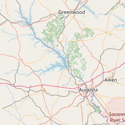
Exact coordinates of the repeater are not known. Location is approximate.

Add a Propagation Report

- Base - HT - Mobile
Click the icons on map for details.


Call Date Details
KQ4JVH (registered) 2024-06-19 Propagation Report Added


Copyright © 2006-2025 RepeaterBook.com. All Rights Reserved.
Created and owned by KD6KPC/WREQ745 since 2006.
All data, including non-copyrightable data, is protected from theft under Oregon law (ORS 164.377).

Page created in 1.671303 seconds.