(1 of 11) ...The Flood Warning continues for the following rivers in Mississippi... Little Tallahatchie Canal at Etta For the Little Tallahatchie River...including Etta...Minor flooding is forecast. * WHAT...Minor flooding is forecast. * WHERE...Little Tallahatchie Canal at Etta. * WHEN...From late Saturday night to late Monday evening. * IMPACTS...At 28.0 feet, Cropland flooding is very extensive and water begins to cover County Road 46. County Road 47 has 1 to 2 feet of water over the unpaved portions. Evacuations become necessary due to access problems. * ADDITIONAL DETAILS... - At 9:00 PM CDT Friday the stage was 12.1 feet. - Forecast...The river is expected to rise above flood stage early Sunday morning to a crest of 27.5 feet Sunday evening. It will then fall below flood stage Monday afternoon. - Flood stage is 25.0 feet. - http://www.weather.gov/safety/flood (2 of 11) ...The Flood Warning continues for the following rivers in Mississippi... Tallahatchie River at Locopolis Tallahatchie River near Lambert Tallahatchie River near Swan Lake For the Tallahatchie River...including Lambert, Locopolis, Swan Lake...Minor flooding is forecast. * WHAT...Minor flooding is forecast. * WHERE...Tallahatchie River near Swan Lake. * WHEN...From Sunday afternoon until further notice. * IMPACTS...At 27.0 feet, Farm land flooding is occurring near the river. * ADDITIONAL DETAILS... - At 9:00 PM CDT Friday the stage was 14.4 feet. - Forecast...The river is expected to rise above flood stage early Sunday afternoon and continue rising to a crest of 27.5 feet Tuesday morning. - Flood stage is 26.0 feet. - http://www.weather.gov/safety/flood (3 of 11) ...The Flood Warning continues for the following rivers in Mississippi... Tallahatchie River at Locopolis Tallahatchie River near Lambert Tallahatchie River near Swan Lake For the Tallahatchie River...including Lambert, Locopolis, Swan Lake...Minor flooding is forecast. * WHAT...Minor flooding is forecast. * WHERE...Tallahatchie River near Lambert. * WHEN...From Sunday morning until further notice. * IMPACTS...At 33.5 feet, Flooding is occurring around Marks and Lambert. * ADDITIONAL DETAILS... - At 9:00 PM CDT Friday the stage was 25.5 feet. - Forecast...The river is expected to rise above flood stage late Sunday morning and continue rising to a crest of 33.0 feet early Tuesday afternoon. - Flood stage is 32.0 feet. - http://www.weather.gov/safety/flood (4 of 11) ...The Flood Warning continues for the following rivers in Mississippi... Tallahatchie River at Locopolis Tallahatchie River near Lambert Tallahatchie River near Swan Lake For the Tallahatchie River...including Lambert, Locopolis, Swan Lake...Minor flooding is forecast. * WHAT...Minor flooding is forecast. * WHERE...Tallahatchie River at Locopolis. * WHEN...From late Saturday night until further notice. * IMPACTS...At 33.0 feet, Flooding is occurring along both banks of the river. * ADDITIONAL DETAILS... - At 9:00 PM CDT Friday the stage was 21.6 feet. - Forecast...The river is expected to rise above flood stage early Sunday morning and continue rising to a crest of 33.5 feet Sunday evening. - Flood stage is 33.0 feet. - http://www.weather.gov/safety/flood (5 of 11) ...The Flood Warning continues for the following rivers in Mississippi... Coldwater River near Sarah Coldwater River at Marks For the Coldwater River...including Sarah, Marks...Moderate flooding is forecast. * WHAT...Moderate flooding is forecast. This approaches the flood of record. * WHERE...Coldwater River near Sarah. * WHEN...Until Wednesday afternoon. * IMPACTS...At 23.0 feet, Flooding is occurring on the left bank. Mainly agricultural land is flooded. The levee system protects the right bank from flooding. * ADDITIONAL DETAILS... - At 9:00 PM CDT Friday the stage was 17.9 feet. - Forecast...The river is expected to rise above flood stage late this evening to a crest of 24.0 feet Sunday morning. It will then fall below flood stage late Wednesday morning. - Flood stage is 18.0 feet. - http://www.weather.gov/safety/flood (6 of 11) ...The Flood Warning continues for the following rivers in Mississippi... Coldwater River near Sarah Coldwater River at Marks For the Coldwater River...including Sarah, Marks...Moderate flooding is forecast. * WHAT...Moderate flooding is forecast. This approaches the flood of record. * WHERE...Coldwater River at Marks. * WHEN...From late Saturday night until further notice. * IMPACTS...At 41.0 feet, Widespread flooding of residential areas and farmland is occurring in northern Quitman county. Numerous secondary roads are flooded. * ADDITIONAL DETAILS... - At 9:00 PM CDT Friday the stage was 35.1 feet. - Forecast...The river is expected to rise above flood stage early Sunday morning and continue rising to a crest of 41.0 feet Tuesday morning. - Flood stage is 39.0 feet. - http://www.weather.gov/safety/flood (7 of 11) ...The Flood Warning continues for the following rivers in Mississippi... Big Black River At West affecting Holmes and Attala Counties. * WHAT...Minor flooding is forecast. * WHERE...Big Black River at West. * WHEN...Until further notice. * IMPACTS...At 17.0 feet, Several thousand acres of agricultural and lowland become inundated. * ADDITIONAL DETAILS... - At 8:45 PM CDT Friday the stage was 11.2 feet. - Forecast...The river is expected to rise above flood stage late Sunday morning and continue rising to 18.0 feet Thursday morning. - Flood stage is 15.0 feet. - http://www.weather.gov/safety/flood (8 of 11) ...The Flood Warning continues for the following rivers in Mississippi... Yalobusha At Whaley affecting Carroll and Leflore Counties. Big Sunflower River At Sunflower affecting Sunflower County. * WHAT...Minor flooding is forecast. * WHERE...Yalobusha at Whaley. * WHEN...From Sunday afternoon to Tuesday evening. * IMPACTS...At 21.0 feet, Lowland flooding is occurring near the river. * ADDITIONAL DETAILS... - At 8:00 PM CDT Friday the stage was 12.2 feet. - Forecast...The river is expected to rise above flood stage Sunday afternoon to a crest of 22.0 feet early Monday morning. It will then fall below flood stage early Tuesday morning. - Flood stage is 21.0 feet. - http://www.weather.gov/safety/flood (9 of 11) ...The Flood Warning continues for the following rivers in Mississippi... Yalobusha At Whaley affecting Carroll and Leflore Counties. Big Sunflower River At Sunflower affecting Sunflower County. * WHAT...Minor flooding is forecast. * WHERE...Big Sunflower River at Sunflower. * WHEN...From Monday morning until further notice. * IMPACTS...At 21.0 feet, Field west of river begins to flood. * ADDITIONAL DETAILS... - At 8:30 PM CDT Friday the stage was 2.1 feet. - Forecast...The river is expected to rise to a crest of 22.0 feet Tuesday morning. Additional rises are possible thereafter. - Flood stage is 21.0 feet. - http://www.weather.gov/safety/flood (10 of 11) ...The National Weather Service in Memphis TN has issued a Flood Warning for the following rivers in Mississippi... Buttahatchie River near Aberdeen For the Buttahatchie River...including Aberdeen...Minor flooding is forecast. * WHAT...Minor flooding is forecast. * WHERE...Buttahatchie River near Aberdeen. * WHEN...From Monday morning until further notice. * IMPACTS...At 14.0 feet, Flood water begins to cover Air Base Road located on the west bank of the river. Low-lying farmland near the river also begins to flood. * ADDITIONAL DETAILS... - At 10:30 AM CDT Friday the stage was 8.8 feet. - Forecast...The river will rise above flood stage Monday morning to 14.1 feet early Tuesday afternoon. - Flood stage is 13.0 feet. - http://www.weather.gov/safety/flood (11 of 11) ...The National Weather Service in Memphis TN has issued a Flood Warning for the following rivers in Mississippi... Tombigbee River near Amory For the Tombigbee River...including Amory...Minor flooding is forecast. * WHAT...Minor flooding is forecast. * WHERE...Tombigbee River near Amory. * WHEN...From Sunday afternoon to late Tuesday evening. * IMPACTS...At 25.0 feet, Widespread lowland and farm land flooding is occurring. * ADDITIONAL DETAILS... - At 10:15 AM CDT Friday the stage was 12.7 feet. - Forecast...The river is expected to rise above flood stage early Sunday afternoon to a crest of 24.2 feet Monday morning. - Flood stage is 20.0 feet. - http://www.weather.gov/safety/flood
RepeaterBook.com Home Page
honey pot Bay Springs, Hospital, Mississippi, 444.925, N5CRS Repeater

Hospital - N5CRS

Bay Springs, MS
Repeater ID: 28-19559

Downlink: 444.92500
Uplink: 449.92500
Offset: +5.000 MHz
Uplink Tone: 179.9
Downlink Tone: 179.9
DMR Enabled
Color Code: 1
DMR ID: DMR ID Needed
County: Jasper
Grid: Em51ix
Call: N5CRS
Use: OPEN
Op Status: ON-AIR On-Air
Coverage:
FM: Yes; analog capable.
Analog Bandwidth: 25.0 kHz (wideband)
Last updated: 2024-09-04
Last reviewed: 2024-09-04
50 km
30 mi
Leaflet | © OpenStreetMap, © OpenStreetMap contributors

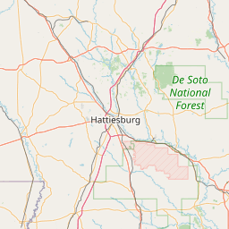
Exact coordinates of the repeater are known.
Coverage circle does not account for propagation anomalies or terrain.

Add a Propagation Report

- Base - HT - Mobile
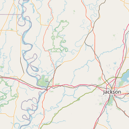
Click the icons on map for details.


Date Information Updated
2020-12-24 00:00:00 Edited ?County? to display correct county, which is Jasper.

Call Date Details
N5CRS (registered) 2024-09-01 Landmark of Jasper General Hospital added. The coordinates were changed. SKYWARN added.
N5CRS (registered) 2024-07-24 Reported on-air.


Visit our DMR pages | Learn more about DMR | NetWatch

- DMR Talk groups are updated directly on radioid.net or BrandMeister.network.
- The IPSC Network is obtained from the radioid.net API. If this information is not correct, please update it at radioid.net.
- Did you know that Repeaterbook has its own BrandMeister talk group? Find us at 31419 (BrandMeister only).

   
If you have an iPhone/iPod/iPad or Android device, please download the FREE official RepeaterBook app!


Copyright © 2006-2025 RepeaterBook.com. All Rights Reserved.
Created and owned by KD6KPC/WREQ745 since 2006.
All data, including non-copyrightable data, is protected from theft under Oregon law (ORS 164.377).

Page created in 0.034990 seconds.